Heavy Rains Block 136 Roads Across Himachal Pradesh
Source:tribuneindia ↗
Why It Matters
Illustrates the real-time vulnerability of the Himalayan terrain to monsoonal hazards, an important topic under regional geography and disaster management for civil service aspirants.
Summary
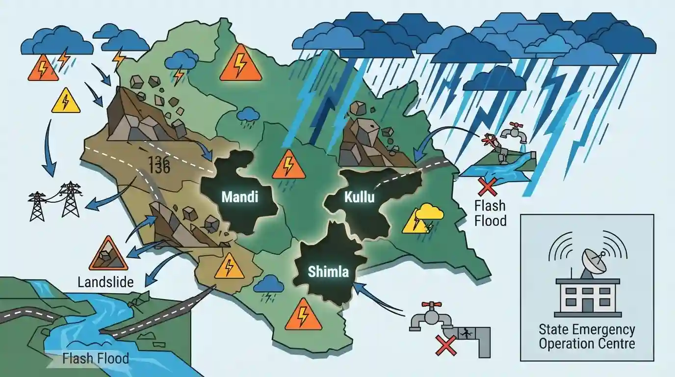
Heavy monsoon rains in Himachal Pradesh have led to the blockade of 136 roads, severe disruption of water and power supplies, and widespread alerts. The State Emergency Operation Centre noted that Mandi, Kullu, and Shimla are the worst-hit districts. The State Meteorological Centre issued 'orange' and 'yellow' alerts across various districts, warning of impending landslides and flash floods, thereby underscoring the severe geographical vulnerability of the Himalayan region during the monsoon.
Key Points
- At least 136 roads were blocked across Himachal Pradesh due to heavy rains, primarily affecting Mandi, Kullu, and Shimla districts.
- The heavy monsoon showers have also disrupted 40 water supply schemes and 111 power transformers.
- The State Meteorological Centre issued an 'orange' alert for heavy to very heavy rains in Mandi and Sirmaur, and a 'yellow' alert for Kangra, Una, Bilaspur, and Chamba.
- Authorities warned of high risks regarding landslides, flash floods, and localized flooding in low-lying and vulnerable areas.
Important Terms
State Emergency Operation Centre

The primary state-level command hub operating under the State Disaster Management Authority to monitor hazards, disseminate warnings, and coordinate emergency response and rescue operations across districts during crises.
UPSC context
GS Paper 3 (Disaster Management). Tests knowledge of institutional frameworks for emergency response under the Disaster Management Act 2005.
State Meteorological Centre
Regional branches of the India Meteorological Department (IMD) tasked with continuously monitoring localized weather patterns, gathering climate data, and issuing critical short-to-medium range forecasts and severe weather warnings.
UPSC context
GS Paper 1 (Geography) & GS 3 (Disaster Management). Relevant for understanding localized early warning systems and monsoon monitoring mechanisms.
Colour-coded Weather Alerts
An early warning system issued by the IMD—using Green, Yellow, Orange, and Red—to indicate the severity of impending weather hazards and dictate the required level of administrative preparedness.
UPSC context
GS Paper 3 (Disaster Management). Tests early warning systems (EWS) and protocol-based administrative readiness for natural disasters.
Flash Floods
Rapid, extreme flooding events occurring within six hours of intense rainfall or cloudbursts. They leave minimal response time and cause severe destruction, particularly in vulnerable topographical regions like the Himalayas.
UPSC context
GS Paper 1 & 3. Crucial for topics on hydro-meteorological hazards, extreme weather events, and mountainous terrain vulnerabilities.
Prelims Trap
The entire state of Himachal Pradesh, including trans-Himalayan districts like Lahaul & Spiti, experiences heavy SW monsoon rainfall.
Trans-Himalayan regions like Lahaul & Spiti lie in the rain shadow of the Great Himalayas and remain arid cold deserts, experiencing very little monsoon precipitation.
Static Concepts Connected
Why are the Himalayas more landslide-prone than the Western Ghats?
- Tectonic Activity: Himalayas are young, active fold mountains undergoing constant tectonic uplift, making rock strata highly unstable.
- Rock Composition: Composed primarily of sedimentary and unconsolidated rocks that lose cohesion rapidly when saturated, unlike stable basaltic Western Ghats.
- Slope Gradient: Extremely steep slopes and high relative relief amplify gravity-driven mass wasting during heavy monsoon downpours.
What defines a meteorological cloudburst?
- Precipitation Rate: Intense rainfall of 100 mm or more per hour over a limited geographical area of about 20-30 square kilometers.
- Orographic Uplift: Warm, moist air is forced rapidly upward by steep mountain barriers, forming rapid, vertically developed cumulonimbus clouds.
Cross-Topic Patterns
Infrastructure vs. Himalayan Carrying Capacity
Linear infrastructure projects like road widening without geological assessments alter slope hydrology, directly linking GS3 economic development with catastrophic landslide and disaster vulnerability.
Climate Change and Cloudburst Frequency
Warming across the Tibetan Plateau alters localized convective patterns, increasing thermodynamic instability and cloudburst frequency, linking GS1 physical geography with GS3 disaster management.

Expect a 2026 GS3 question linking Himalayan ecological carrying capacity with the NDMA's National Landslide Risk Mitigation Strategy.
Linked PYQs · 3
Linked PYQs · 3
- 2024HPAS_PRELIMSGS1
Arrange the following climatic zones of Himachal Pradesh according to rainfall amount from lowest to highest : (1) Frigid aridic zone (2) Wet temperate zone (3) Humid sub-tropical zone (4) Sub-humid sub-tropical zone Choose the correct answer from the options given below :
- 2023HPAS_PRELIMSGS1
Consider the following statements : (1) The rainiest district in Himachal Pradesh is Kangra. (2) Rainfall in the Alpine region of Himachal Pradesh varies between 300-600 mm. (3) Winter season in Himachal Pradesh extends from October to March. (4) Mandi is the hottest place in Himachal Pradesh. Choose the correct answer from the options given below :
- 2025HPAS_PRELIMSGS1
Match List I with List II : | List-I (Code) | List-II (District) | |---|---| | (a) Highest Rainfall (2018 Data) | (i) Shimla | | (b) Second Most Incidents Reported (2024 Crime Data) | (ii) Mandi | | (c) Fourth Highest Population (2011 Census) | (iii) Kangra | | (d) Fourth Largest Area | (iv) Solan | Choose the correct answer from the options given below : Code: (a) (b) (c) (d)
